GIS Cloud Suite
Open Geoprocessing Service
GIS Cloud Suite supports to open Geoprocessing Service, please see the following steps:
- Clicks Service Management > Geoprocessing Service on the left navigation bar;
- Clicks on Enable;
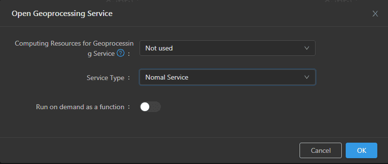
- Select the Computing Resources and Service Type used by the geoprocessing service, and select whether to run as a function on-demand. The service type can be either normal service or machine learning enabled. Click the OK button, as shown in the following figure:
Select the Computing Resources:
- Not used: Do not configure computing resources and use local mode for task calculations.
- Built-in Hadoop YARN: Use the built-in computing resource Hadoop YARN for task calculation. To enable the built-in Hadoop YARN, please refer to Computing Resources ->Hadoop YARN Cluster ->Add Hadoop YARN Cluster.
- External Hadoop YARN (actually displayed as the name of the external Hadoop YARN): Use your own Hadoop YARN cluster for task calculations. To add your Hadoop YARN cluster to the GIS cloud suite, please refer to Computing Resources ->Hadoop YARN Cluster ->Add External Hadoop YARN Cluster. At the same time, you also need to configure the hostname of the machine learning service in the host file of the machines where each node of the Hadoop YARN cluster is located. The configuration format is {ip} iserver-geoprocessing, and {ip} is the IP address of the machine where the Kubernetes service Master node of the GIS Cloud Suite is deployed.
Select Service Type:
- Normal Service: services provided by the geoprocessing automation model built by the general geoprocessing automation tools, which include component tools and big data tools modules.
- Machine Learning Services: services provided by machine learning module tools for constructing geoprocessing automation models, including spatial deep learning, etc. For details, please refer to the SuperMap iServer help document .
Enable/disable run as a function on-demand .
- Wait for the Status change to “1/1”, then Geoprocessing Service is ready to use;
- Clicks on the link under the Address to enter the Geoprocessing Service interface.
The link above the address allows you to enter the Geoprocessing Modeler page to build a model and run it. The link below the address allows you to enter the geoprocessing service page, and click to view the tool and task list for geoprocessing services. The tool list page includes Data metainformation extraction, Big data 3D cache generation tool, and other tools.
Note:
- Please refer to the SuperMap iServer help document for the usage of geoprocessing service.
- To enable machine learning services, you must first enable the machine learning service on this page. For the method of opening machine learning service, please refer to Service Management ->Machine Learning Service ->Opening Machine Learning Service.

